
Edinburgh Council spent considerable time and money developing a "Street Design Guidance Manual". A bases for all future projects in Edinburgh.
http://www.edinburgh.gov.uk/info/20089/roads_and_pavements/906/edinburgh_street_design
It states:-
- Strategic streets: absolute min. 2.5m (only allowed in short sections), general min 3m, desirable min 4m or wider.
- Provide pedestrian phases on all signalised junction arms and consider X (all green) crossing.
- Providing new crossings on desire lines
- Provide pedestrian crossing points (controlled or uncontrolled crossings) every 50-100m
- Prioritizing pedestrians, cyclists and public transport
- No new vehicular footway crossovers to be introduced on strategic and secondary streets.
Areas of concern - from Princes Street northwards
No proposed crossing from North Bridge east side direct to St James. 2 separate crossings required (red)

New "no left turn" from Leith Street in to Waterloo Place, and York Place in to Broughton Street. As per elsewhere in Edinburgh these kind of banned turns are frequently ignored, putting pedestrians at great risk as they have a green man. Examples include Haymarket, Lothian Road / Fountainbridge, Ardmillan, Ashley / Slateford, Foot of the Walk


Narrow pavement at 2 meters. Rest of pavement to north and south is 4meters. This will create a bottleneck. SDG states ABSOLUTE MINIMUM 2.5m

Pavement space lost to new building. New pavement should have been at least 4 meters

Narrow pavements at crossing points.

2 Pedestrian crossing points missing - "Provide pedestrian phases on all signalised junction arms"

Conflict between pedestrians crossing (highlighted) and cyclists

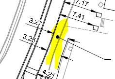
Narrow Pavement at 3.25m. Surrounding pavements much wider at 4.21m and 7.4m. This creates a bottleneck.
Narrow pavement at 2.89m. This area is at the top of a long set of stairs.


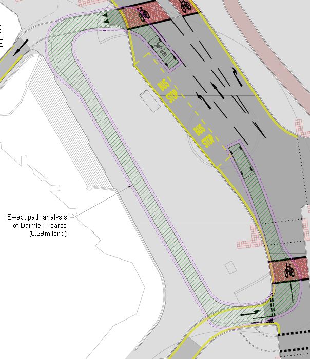
New Bus stop on Leith Street north side, doesn't leave much room for pedestrians to pass the stop. This was a very busy stop previously.

Area highlighted is red has been redefined as a cycle path - even though this is a major pedestrian crossing point. Cycle path dumps cyclists in amongst pedestrians.


From the RSO / TRO - the red line outlines the area to be converted from road and pavement to a cycleway. Are pedestrians supposed to cross the cycleway? How can they do that safely?

Currently a 4 lane, 2 stage crossing to cross between Omni Centre and John Lewis. Will be a 3 stage 5 lane crossing.

Cycle way dumps cyclists on pavement

Multiple crossings in the same place will cause confusion


Large pedestrian area created outside St Marys Cathedral. Council has already planned for vehicles to drive over it. What will stop this area becoming a car park?

Cathedral lane bisects the new pedestrian area. Given Cathedral Lane dosn't provide vehicle access to any buildings, has very narrow pavements at 60cm, and other vehicle routes are available via Elder Street, why not close the road?

Narrow pavement outside the Conan Doyle Pub. This narrow area is already taken up by outdoor seating and advertising boards from the pub.

Cyclists have a give way line at a pedestrian crossing. Will cyclists give way when pedestrians have a green man?
 .
. 
Cyclists from Broughton Street will have a dedicated cycle lane round the corner in to Picardy Place. The exit for this lane is at the pedestrian crossing, with no give way, zebra etc.

To access the York Place tram stop is currently a 1 stage crossing from York Place. From the Conan Doyle pub it will be a 3 stage, or from St Pauls and St Georges it will be a 2 stage.

It's currently a busy 2 stage crossing from Conan Doyle pub, crossing 3 lanes of traffic. Plans will make it at least a 3 stage crossing. Current path in Red, new path in Blue.

Cycle crossing point dumps cyclists on narrow tram stop platform

The pavement on Picardy Place is alongside a very quiet narrow street. Plans show it alongside 3 lanes of busy traffic.

Current 2 stage crossing outside the Playhouse will become a much wider 3 stage crossing. currently crosses 4 lanes of traffic, plan shows 3 lanes of traffic, 2 tram tracks and a cycle lane. A comparable crossing is on york Place at the junction with elder Street, where it can take over 4 minutes to cross the road given the traffic light sequence. Every year the crossing is taking longer and longer.
https://youtu.be/0v9KinkUbBA

Noticeable that Edinburgh Council continues to promote images of a traffic free gyratory (left). The image on the right is only half way to being realistic.


